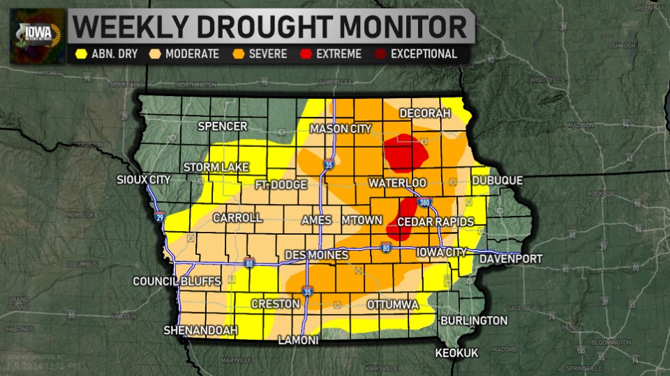
MONITOR


OUTLOOKs


CHANGE OVER TIME


PRECIP. NEEDED TO END

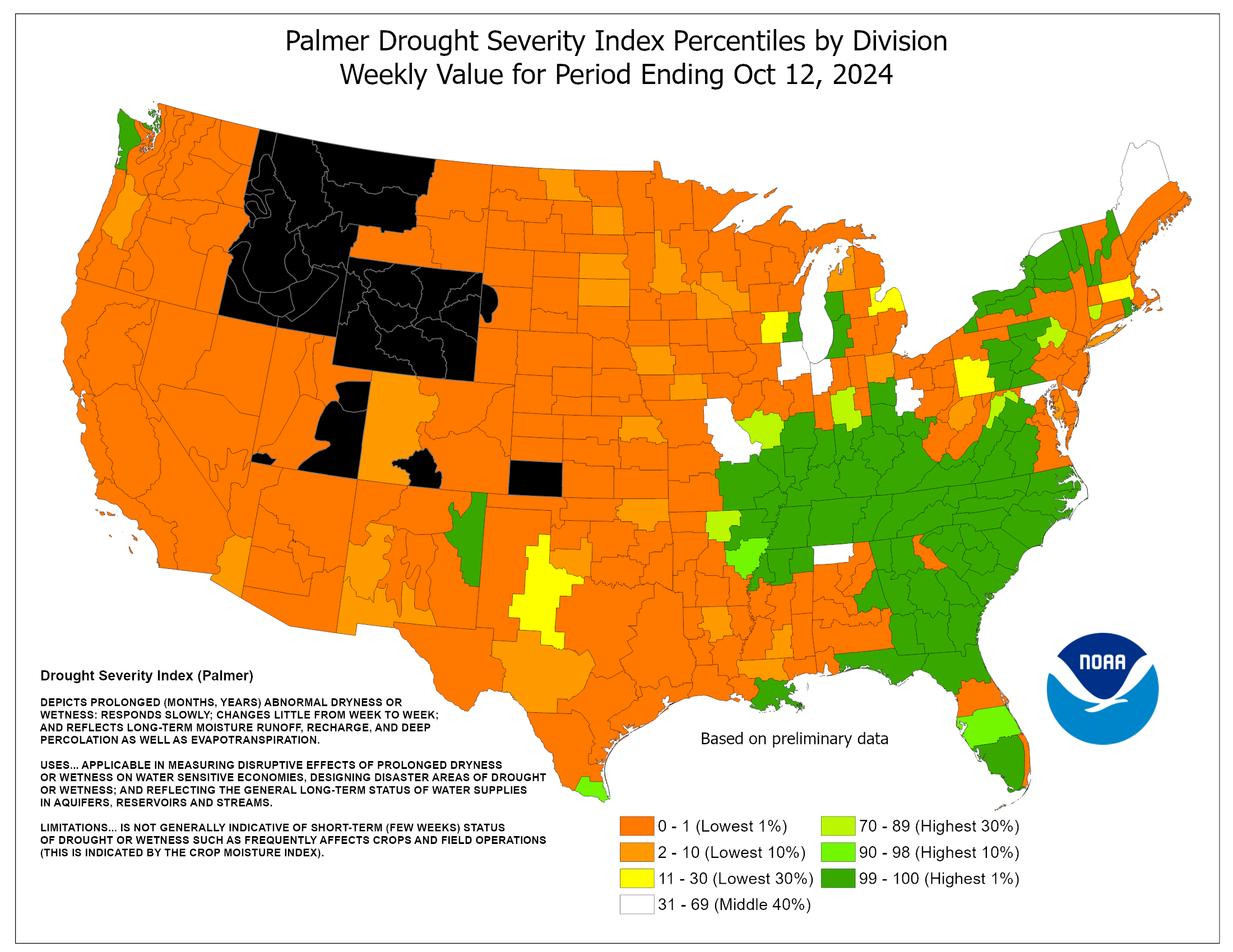
PALMER DROUGHT INDEX


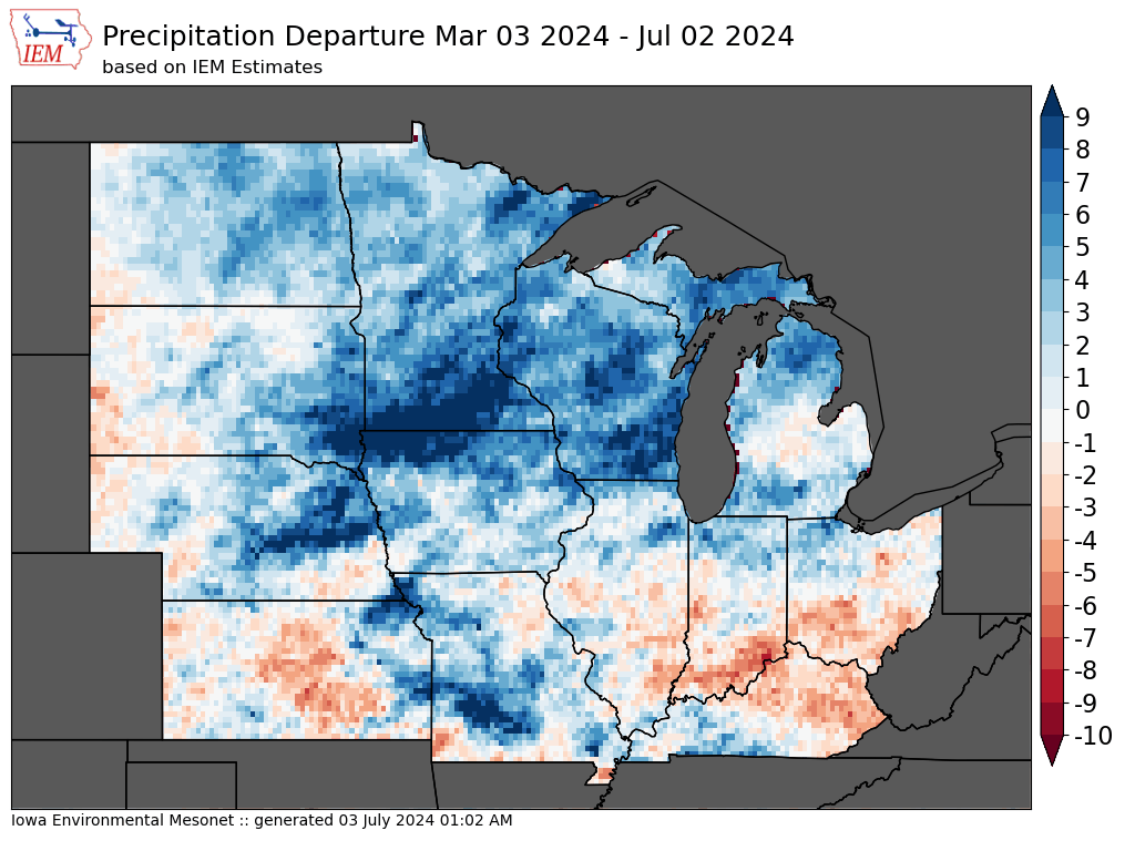
DEPARTURES

VEGETATION (VegDri)


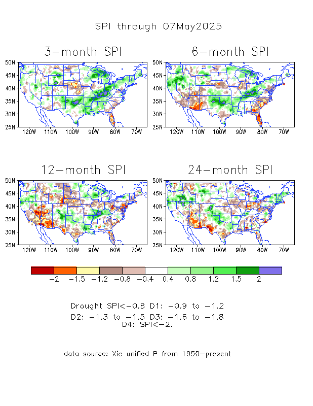
STANDARD PRECIP INDEX
TOPSOIL MOISTURE

STATISTICS
| Week | Date | None | Abnormally Dry | Moderate | Severe | Extreme | Exceptional | DSCI |
|---|---|---|---|---|---|---|---|---|
| Current | 2024-04-16 | 14.71 | 85.29 | 66.20 | 30.68 | 7.43 | 0.00 | 190 |
| Last Week | 2024-04-09 | 14.72 | 85.28 | 67.33 | 32.14 | 10.55 | 0.00 | 195 |
| Three Months Ago | 2024-01-16 | 3.69 | 96.31 | 80.05 | 63.04 | 27.80 | 0.00 | 267 |
| Start of Calendar Year | 2024-01-02 | 2.77 | 97.23 | 83.41 | 65.09 | 35.18 | 0.00 | 281 |
| Start of Water Year | 2023-09-26 | 0.01 | 99.99 | 95.65 | 67.41 | 25.00 | 1.17 | 289 |
| One Year Ago | 2023-04-11 | 37.97 | 62.03 | 31.90 | 15.51 | 1.51 | 0.57 | 112 |
DISCUSSION
Heavy precipitation fell across much of the central and eastern parts of the country, bringing improvements along the Mississippi River and Great Lakes regions. There were also isolated areas of improvement in Oregon, Idaho and Montana. Extreme drought conditions were introduced in the mountainous region along the Idaho and Montana border due to concerns about low snow amounts and possible early snowmelt. Across the country in the Southeast, areas in North Carolina and southern Florida are seeing drying conditions due to low precipitation over the past few weeks. Western and southern Texas, which largely missed this week’s precipitation, saw an expansion of abnormal dryness, moderate and severe drought conditions. Flash drought conditions are appearing in Oklahoma, and Kansas, with some spillovers in eastern Colorado and western Missouri. Weeks with little precipitation, warming temperatures, dry soils and low streamflow levels are leading to rapid degradations.
The National Weather Service Climate Prediction Center’s 6 to10-day outlook (Valid April 22) favors above-normal precipitation for southern parts of the U.S., particularly along the eastern Gulf Coast from Texas and Louisiana into parts of Arkansas and Oklahoma. Florida is also favoring above-normal precipitation. The Northwest and Northeast are leaning towards below-normal precipitation. From the middle of Pennsylvania northward, below-normal precipitation is likely to occur. Hawaii is also leaning towards below-normal precipitation and Alaska is leaning towards above-normal precipitation. In terms of the temperature outlook, above-normal temperatures are expected from the West into the High Plains, as well as along the Gulf Coast and Florida. Utah, Nevada, northern Arizona, northern New Mexico and western Colorado are showing a 70-80% likelihood of above-normal temperatures. Eastern Alaska is also leaning towards above-normal temperatures. The Mid-Atlantic region and the eastern Midwest are leaning toward below-normal temperatures. Hawaii and western Alaska are favoring below-normal temperatures.
Forecast
Over the next 5 days (April 19-23), more heavy precipitation is expected in the Plains and Midwest. Iowa, Nebraska and South Dakota could see upwards of 2.5 inches of precipitation. Northeast Texas, southeastern Oklahoma, and western Arkansas could see 1.5 to 2 inches of precipitation. Areas of higher elevation in the Rockies of Colorado and Wyoming are also expected to see between 1-2 inches.The National Weather Service Climate Prediction Center’s 6 to10-day outlook (Valid April 22) favors above-normal precipitation for southern parts of the U.S., particularly along the eastern Gulf Coast from Texas and Louisiana into parts of Arkansas and Oklahoma. Florida is also favoring above-normal precipitation. The Northwest and Northeast are leaning towards below-normal precipitation. From the middle of Pennsylvania northward, below-normal precipitation is likely to occur. Hawaii is also leaning towards below-normal precipitation and Alaska is leaning towards above-normal precipitation. In terms of the temperature outlook, above-normal temperatures are expected from the West into the High Plains, as well as along the Gulf Coast and Florida. Utah, Nevada, northern Arizona, northern New Mexico and western Colorado are showing a 70-80% likelihood of above-normal temperatures. Eastern Alaska is also leaning towards above-normal temperatures. The Mid-Atlantic region and the eastern Midwest are leaning toward below-normal temperatures. Hawaii and western Alaska are favoring below-normal temperatures.